In fantasy RPGs, and in some other theme-forward RPGs, maps are often assumed to be one of the high-impact setting artifacts. They’re great for demonstrating production value, they provide valuable in-game information, and they’re good goal-setting tools that inspire their players to seek out far off and challenging destinations. Heck, “map fantasy” is an entire sub-genre of literature.
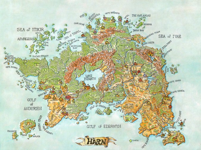
This map makes me want to play this game.
A conversation in one of my online communities recently got me thinking about what maps suggest, however. While I don’t have an issue with maps, in general, I often find myself working with with much less precise geography when I run games. I responded that GMs could also use flowcharts instead of maps, and I wanted to explore that more substantially here.
Some of things that come up when discussing maps:
- When your fantasy campaign/ scenario/ session relies on a map, that document makes many decisions for you, rather than letting them emerge from the gameplay. A savvy GM can deviate from this, but it becomes a little more difficult to account for than changing an antagonist or substituting a faction. There’s a cascade effect of consequences that changing “map truths” has, not the least of which is invalidating some of the visual verity of game materials designed for that very purpose. Certainly, fantasy and games are about imagining “what if?” but if the tools for doing that reinforce a different what if, they’re fighting the player’s sense of authenticity.
-

Hexcrawl nerd nirvana, from Tomb of Annihilation.
If the mapped area is known, that diminishes some of the discovery incentive for exploring the area. Put in practical terms, there’s a reason that Tomb of Annihilation has a huge number of unknown hexes on its player map. It’s an encouragement to seek the answer to a question the game asks. If the players’ map was filled in, it’s simply an exercise in choosing the perceived optimal route. But when the players are able to fill it in because they found the answer, that’s intrinsically rewarding! They’ve pushed back the unknown themselves, which is extremely satisfying. In a perfect world, your players may be the ones to make the map and introduce it to the world (or keep it secret). But those decisions and outcomes are the stuff of which games are made, yes?
- Assuming a semi-medieval information state and economy, maps are extremely valuable, and the information they contain isn’t necessarily common knowledge. This is less important in worlds with magic and million-year written traditions and infinite non-exploitative production means, but overall, if your world assumes some historical affections and not others, that makes it more difficult for the players to understand which of the unspoken truths are in fact different. Not a huge issue, but a seeming incongruity with certain assumptions of authenticity.
Again, my intent is not to eliminate map use, but to provide an immediately useful and perhaps more relevant alternative. Especially as a GM, you may need more or different information more readily at hand than a traditional map provides.
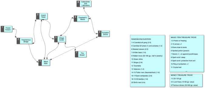
A dungeon arrayed as a flowchart rather than a traditional gridded map. The dotted line indicates a secret passage. The numbers correspond to encounter details on a legend (not depicted). Note the one-way path from the Treacherous Bridge to the Black Idols — reaching the idols this way probably means falling from the bridge!
I’m reminded of an early Robert E. Howard sketch of his fantasy world as he envisioned it*, which didn’t have a map paired with it. rather, it was a description of the various lands and the themes they evoked, but with a very impressionistic description of their locations, largely in relation to the other locations. This seemed to me a clever narrative way of handling things — I know that Area X is off to the badlands of the west and Region Y is mired in the swampy southeast and that’s pretty much all I need because I’m reading about story events rather than planning a road trip to either location.

This dude is pretty sure he’s within a day or two’s travel from Greyhawk.
In my experience, that’s the most important determinant: Is the destination more important than the journey, in terms of how the game is set up? For example, if the game is planned as a series of narrative events planned at key set piece locations, the actual map geography becomes less important. If the game is planned as a hex crawl or a journey into the unknown, a map is more important — and the players may even be creating a map of their own, perhaps even the only such map that exists in the world! OSR gameplay, for example, often emphasizes travel to the destination, while many more narrative games focus on the planned encounter locations instead of the interstices.
Replacing the Map With a Flowchart
When the fine details of a map aren’t critical to the gameplay decisions, I can set to work building the flowchart. Even “flowchart” implies more structure than is necessary, as it suggests dependent, sequential movement. A simple chart, showing relative position, is really all you need. You can build these with heavy tools like Power Point (not optimal) or Visio (better, as it preserves the spatial relationships and connections). I’ve found, though, that lighter mindmapping programs work best. I use Scapple most often and sometimes MindNode (which I also use to collect campaign details, plot events, and player responses). Different programs should also let you use different shapes and connector types that give you visual cues of different information types.
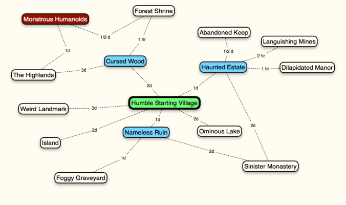
Here’s a map chart of a local-scale campaign environment. The green location is the starting locale, and probably the one best known to the PCs. The blue entries are the areas that PCs can gain rumors about while asking around the village. The uncolored entries are feature areas — dungeons, buildings, interesting places. The red entry is a planned encounter tied to a specific area proximate to other nearby features. The numbers on the dotted lines are travel distances expressed as times, which can be used for random encounter checks or for time-dependent events.
Things to Include in a Map Chart
- Spatial relationships of geographical entries
- Include sequential travel relationships. For example, if you have to go under the mountain to get to the castle on the other side, the chart should depict that dependency
- This also lets you array the alternate routes. In the example above, it may be safer but longer to travel through the forest to get to the castle, but faster and more dangerous to go under the mountain
- Distance between geographical entries
- Stated as a value; will usually fit on connector lines
- Some differentiation between geographical entries of different types
- E.g. Region vs community vs geographical feature vs adventure site vs encounter
- Use different colors to denote different entities (cities in one country all have a blue background, all dungeons with artifacts have a yellow-highlighted header, etc.)
- References to relevant encounters
- If you want to get sophisticated and interactive, you can link from the map chart to wiki entries, Trello cards, Obsidian Portal campaigns, etc.
* “Notes on Various Peoples of the Hyborean Age,” “The Hyborean Age,” and “Hyborian Names and Countries,” pp. 375, 379, and 417, from The Coming of Conan the Cimmerian
